

Satellite latency is the delay in data transmission between vessels and remote systems due to the distances signals travel to and from satellites. For maritime operations, this delay impacts navigation, safety, fleet management, and onboard services. Key points:
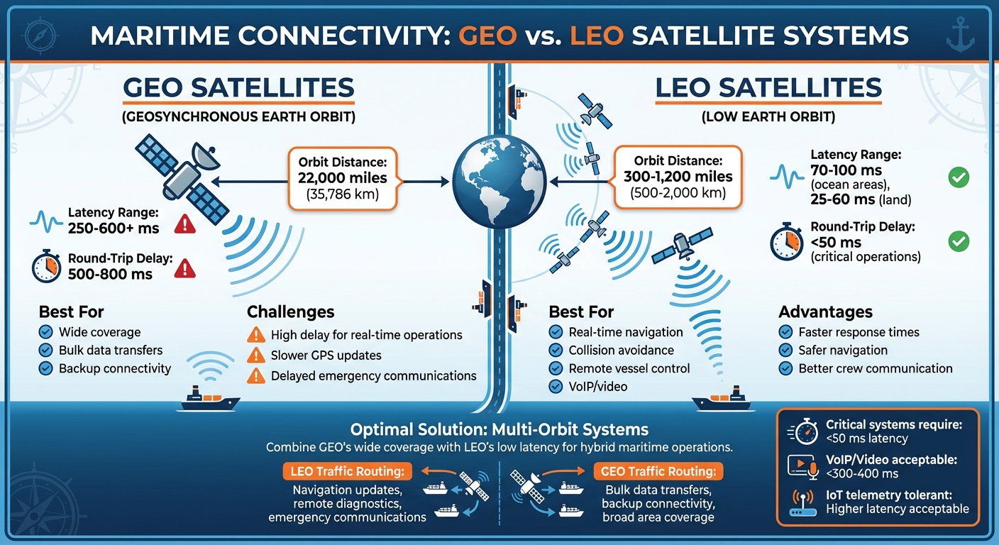
- GEO vs. LEO Satellites: Geostationary (GEO) satellites have higher latency (250–600+ ms) due to their 22,000-mile orbit, while Low Earth Orbit (LEO) satellites offer lower latency (70–100 ms in ocean areas) because they orbit closer to Earth.
- Challenges at Sea: Harsh weather, ship movement, and satellite handoffs increase latency, causing issues like delayed GPS updates, slow telemetry data, and unreliable communication services.
- Solutions: Multi-orbit systems (GEO + LEO), onboard traffic management, and optimized protocols help reduce latency. NT Maritime specializes in such systems, prioritizing critical operations while improving crew and passenger connectivity.
Quick Takeaway:
Lowering satellite latency with LEO satellites, traffic prioritization, and smart network design ensures smoother maritime operations, safer navigation, and better onboard experiences.
GEO vs LEO Satellite Latency Comparison for Maritime Operations
What Causes Satellite Latency in Maritime Networks
Satellite Orbits and Signal Distance
The main reason for satellite latency is the distance signals need to travel. Geostationary (GEO) satellites, positioned much farther from Earth, naturally introduce more latency compared to Low Earth Orbit (LEO) satellites. LEO satellites, orbiting just a few hundred to about 1,200 miles above the planet, can reduce latency to around 25–60 milliseconds on land and about 70–100 milliseconds in remote ocean regions. To address this, NT Maritime uses multi-orbit systems, which combine GEO’s wide coverage with LEO’s low latency. For instance, they route critical tasks like navigation updates and remote diagnostics through LEO, while bulk data transfers are handled by GEO. Essentially, the satellite’s altitude and the distance signals must travel play a crucial role in the overall performance of maritime networks.
Environmental Factors at Sea
Environmental challenges at sea add another layer of complexity to managing latency. Ships navigating rough waters rely on stabilized antennas to maintain satellite connections. However, misalignments caused by obstructions or the mechanical limits of these systems can lead to brief outages, forcing retransmissions that increase latency. Additionally, severe weather, such as heavy rain or storms, can weaken signals on higher-frequency Ku- and Ka-band links. This often forces systems to switch to lower modulation schemes, which come with higher error rates. During such conditions, latency spikes and reduced throughput are common, as local rain fade disrupts the initial connection between the ship and the satellite.
Network Design and Application Requirements
The design of maritime satellite networks also impacts latency. Many services use shared bandwidth models, meaning multiple vessels compete for resources on the same beam or carrier. During peak usage times, this competition can lead to network congestion, causing latency and jitter to rise. For applications like VoIP and video conferencing, this can result in awkward delays and choppy communication when round-trip times exceed 300–400 milliseconds. Meanwhile, critical systems such as navigation and remote vessel controls demand latencies under 50 milliseconds to function safely and efficiently. While IoT telemetry for tasks like engine monitoring and fuel optimization can handle higher latency, performance may degrade when protocols requiring quick acknowledgments face congested, high-delay links. Without proper onboard traffic prioritization and Quality of Service (QoS) measures, non-essential activities like streaming or guest Wi-Fi can overwhelm the network, leaving vital systems struggling for bandwidth.
How Latency Affects Maritime Operations
Navigation and Safety Systems
Satellite latency has a direct impact on maritime operations, particularly in navigation and safety systems. GEO satellites, for example, can introduce delays ranging from 250 ms to 800 ms. This lag can slow the delivery of crucial GPS updates, collision avoidance alerts, and emergency communications. When shore-based teams or remote pilots rely on live video feeds and real-time data to guide vessels through congested areas or narrow channels, even minor delays can jeopardize safe navigation.
Outdated weather updates and chart corrections add to the risks. Ships operating with old information face a higher chance of collisions or groundings, especially in busy shipping lanes or during rapidly changing conditions. Emergency coordination also becomes more challenging, as delays in distress signals or inter-vessel communication can slow down critical response efforts.
Fleet Management and IoT Systems
Latency also disrupts fleet management by delaying the transmission of telemetry data essential for real-time decisions. Key tasks like monitoring engine performance, optimizing fuel usage, and performing predictive maintenance rely on timely sensor updates. Delays in this data can prevent maintenance teams from addressing issues quickly, leading to higher operational costs and unplanned downtime.
Additionally, high latency hampers real-time tracking of vessels and cargo, complicating route planning and performance analysis. These delays not only affect fleet efficiency but also degrade the overall quality of communication across the network, making it harder to maintain seamless operations.
Crew and Passenger Services
For crew and passengers, high latency takes a toll on communication and internet services. Video calls, VoIP, and onboard internet become unreliable, negatively impacting crew morale and passenger satisfaction. These connectivity issues highlight the importance of prioritizing onboard traffic to ensure that critical systems remain unaffected.
Without effective traffic management and Quality of Service (QoS) policies, passenger Wi-Fi usage can overwhelm the network, disrupting essential bridge systems and operational communications. To address these challenges, NT Maritime offers integrated communication solutions tailored for maritime environments. Their systems prioritize traffic and use low-latency connectivity to ensure reliable performance for both mission-critical operations and crew welfare, including onboard calling, messaging, and video services.
How to Reduce Satellite Latency in Maritime Operations
Network Architecture Improvements
Switching from GEO (geostationary) satellites to LEO (low Earth orbit) satellites can significantly lower latency. For reduced-crew vessels, having communications networks with round-trip latency under 50 milliseconds is critical to ensure safe operations. This is why multi-orbit systems, which combine both types of satellites, are becoming increasingly important.
Multi-orbit connectivity takes advantage of the strengths of both GEO and LEO satellites. By using a combination of GEO satellites with software-defined capabilities and low-latency LEO satellites, shipping companies can optimize their communication networks. LEO satellites handle time-sensitive tasks like real-time navigation and collision avoidance, while GEO satellites cover broader areas and act as a backup. With dynamic network orchestration, the system automatically routes critical data through the fastest available connection, ensuring the lowest possible latency in real time. This software-driven approach makes connectivity more responsive, adapting to changing operational needs.
To build on these improvements, effective onboard traffic management is key to minimizing latency’s impact.
Onboard Traffic Management and QoS Policies
Managing onboard traffic effectively ensures that latency-sensitive tasks, such as navigation and safety systems, are not disrupted. This requires traffic segmentation and QoS (Quality of Service) prioritization. Ships can achieve this by setting up separate VLANs for bridge and safety systems, business operations, and crew or passenger services. Operators should also establish strict QoS limits for non-critical services and guest devices to prevent them from using bandwidth needed for essential systems like engine monitoring and emergency operations.
Another strategy is local caching, which stores frequently used data – such as charts, weather updates, and software patches – onboard. This reduces the need for repeated satellite communication, improving overall performance for users at sea. NT Maritime integrates these principles into their communication systems, prioritizing mission-critical operations while also supporting crew welfare with reliable services for calling, messaging, and video.
Application and Protocol Optimization
Beyond network and traffic strategies, optimizing applications and protocols can further enhance performance. Using protocols like QUIC and HTTP/3 can reduce handshake delays and increase throughput on high-latency links. For VoIP and video applications, adaptive codecs with jitter buffers and error correction help maintain quality even when latency varies.
WAN acceleration tools designed for satellite environments offer additional benefits. These tools provide TCP acceleration, compression, and application-specific tweaks to enhance responsiveness for remote desktops, VPNs, and cloud-based dashboards. Operators should test network performance under real-world conditions, as satellite links often exceed 100 milliseconds of latency. Real-time monitoring systems can track link quality and congestion, automatically adjusting bandwidth allocation when performance drops. This proactive management ensures that latency-sensitive services remain reliable, aligning with NT Maritime’s goal of maintaining resilient and efficient communications for maritime operations.
sbb-itb-bda822c
LEO Sat Transition: Starlink Maritime, OneWeb, Kuiper

Conclusion: Planning for Low-Latency Maritime Connectivity
Planning for low-latency maritime connectivity has become a priority as satellite latency directly impacts navigation, decision-making, and operational efficiency. Traditional GEO links introduce delays of over 250 ms, while LEO and multi-orbit systems significantly lower latency to 70–100 ms.
To adapt, maritime operators need a robust connectivity roadmap. This roadmap should sync vessel upgrades, contract renewals, and digital initiatives with specific latency and uptime goals. Start by identifying latency-sensitive applications and assessing the potential benefits of LEO or hybrid GEO–LEO systems.
Evaluate the performance of existing networks by measuring latency, jitter, and uptime across current routes. Use this data to perform a gap analysis and consider piloting LEO or hybrid solutions on select vessels to test their effectiveness before committing to a full-scale rollout.
Reliable connectivity also requires balancing low latency with redundancy. To ensure uninterrupted communication during outages, diversify satellite paths, establish clear fallback protocols, and strengthen cybersecurity. This includes secure network architectures, segmentation, and regular managed updates. These steps help create resilient networks capable of supporting critical operations.
NT Maritime offers multi-orbit network solutions designed to meet these demands. Their secure, IoT-ready systems enable real-time monitoring, remote maintenance, and improved onboard communication across commercial, cruise, and government or military fleets. Collaborating with NT Maritime early allows operators to co-develop a tailored roadmap that incorporates multi-orbit connectivity, onboard network upgrades, QoS policies, and application optimization – all aligned with the unique needs and budgets of their fleets.
FAQs
How do multi-orbit satellite systems benefit maritime communication?
Multi-orbit satellite systems bring a new level of reliability to maritime communication by leveraging the advantages of various satellite orbits. This approach ensures wider coverage, faster response times, and more consistent connectivity. Ships can stay connected with stable, high-speed internet, even in the most remote or demanding locations.
These systems are designed to enable smooth transitions between different satellite networks, minimizing delays and ensuring real-time data transfer. This is crucial for essential maritime tasks such as navigation, communication, and safety operations. Their ability to maintain uninterrupted service makes them an essential tool for modern maritime connectivity.
What challenges does satellite latency pose for maritime operations?
Satellite latency, particularly with Geostationary Earth Orbit (GEO) satellites, poses notable challenges for maritime operations. The sheer distance that signals must cover leads to delays, which can interfere with real-time communication and slow down critical decision-making.
These delays affect various aspects of maritime activities, including navigation updates, crew communication, and passenger services. This can ultimately hinder operational efficiency. To tackle these issues, advanced communication technologies are often needed to reduce latency and ensure more seamless operations while at sea.
How can maritime operators manage traffic to minimize the effects of satellite latency?
Maritime operators can tackle satellite latency issues by using Quality of Service (QoS) protocols. These protocols prioritize essential communication tasks – like navigation updates or emergency signals – so they get more bandwidth and experience fewer delays.
Another effective strategy is traffic shaping, which helps allocate bandwidth based on operational needs. By doing this, critical systems stay functional even when network demand is high. Optimizing traffic flow ensures that communication remains steady and dependable, no matter the conditions at sea.